- Subscribe to RSS Feed
- Mark Topic as New
- Mark Topic as Read
- Float this Topic for Current User
- Bookmark
- Subscribe
- Mute
- Printer Friendly Page
getting map images
04-04-2007 03:27 PM
- Mark as New
- Bookmark
- Subscribe
- Mute
- Subscribe to RSS Feed
- Permalink
- Report to a Moderator
How do I get map data into a picture control onto which I can plot my gps data?
Mac 10.4
LV7.1
CLD
04-04-2007 03:48 PM - edited 04-04-2007 03:48 PM
- Mark as New
- Bookmark
- Subscribe
- Mute
- Subscribe to RSS Feed
- Permalink
- Report to a Moderator
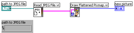
I assume you mean you have a picture of the map and want to put it into a picture control. Under the graphics formats palette, you can find VIs to read in an image file. You can then take this image data cluster and add it to a picture control as shown in the attachment.
Message Edited by Marc A on 04-04-2007 04:49 PM
04-04-2007 04:05 PM
- Mark as New
- Bookmark
- Subscribe
- Mute
- Subscribe to RSS Feed
- Permalink
- Report to a Moderator
Since, I wrote my original post, I found a wonderful example of hw to get images from http://terraserver-usa.com. This example by vivi is found at
http://forums.ni.com/ni/board/message?board.id=170&message.id=151065&query.id=118173#M151065
In this example, the images are downloaded from http://terraserver-usa.com using a formatted request. The topo maps on this server are not near the quality of Google maps or Mapquest, but the aerial photos may be useable for my application. I will probably follow vivi's example for obtaining aerial photos and overlay my data on them.
I should comment that the example is very complete, containing functions for scaling and converting lat-long pairs to projected points for distance calculations. It is a remarkable example of code sharing. vivi is da bomb!
Mac 10.4
LV7.1
CLD
04-06-2007 07:37 PM
- Mark as New
- Bookmark
- Subscribe
- Mute
- Subscribe to RSS Feed
- Permalink
- Report to a Moderator
04-08-2007 11:07 AM
- Mark as New
- Bookmark
- Subscribe
- Mute
- Subscribe to RSS Feed
- Permalink
- Report to a Moderator
The Web-based Google Maps API may be the easiest and most flexible solution of all, if you're willing to:
1) use an ActiveX control (Internet Explorer here) in your LabVIEW panel, and
2) host a simple external Web page (or rely on someone else's page) to produce the map/overlay object for you to display
I've been looking for an excuse to play around with Google Maps for a while now, and your post spurred me into action. Attached is a VI (LV 8.0, sorry) that is a bit simpler than vivi's example. It allows you to specify a center point, zoom level, and list of lat/long points for which to display a path on the map. The Web page that produces the map image is hosted on my site for the sake of demonstration, but I included the HTML source in the VI so that you could easily transplant it to your own Web server if you want to pursue this approach.
There are other map-related examples posted in the forums besides mine and vivi's, but I didn't see one that addressed this specific need, so I figured I'd post mine. Let me know what you think.
Take care,
John
04-09-2007 01:43 PM
- Mark as New
- Bookmark
- Subscribe
- Mute
- Subscribe to RSS Feed
- Permalink
- Report to a Moderator
You guys hit the nail on the head with these responses. Y'all (yes, from the south) this forum awesome! I can't wait to try your example on a machine running LV8.0. Thanks. I'll be sure and give you feedback on your example when I get to run it.
Mac 10.4
LV7.1
CLD
04-09-2007 01:47 PM
- Mark as New
- Bookmark
- Subscribe
- Mute
- Subscribe to RSS Feed
- Permalink
- Report to a Moderator
Mac 10.4
LV7.1
CLD
04-20-2007 09:58 PM
- Mark as New
- Bookmark
- Subscribe
- Mute
- Subscribe to RSS Feed
- Permalink
- Report to a Moderator
Thanks again for your contribution to this thread.
Mac 10.4
LV7.1
CLD
