Using Google Maps in LabVIEW
- Subscribe to RSS Feed
- Mark as New
- Mark as Read
- Bookmark
- Subscribe
- Printer Friendly Page
- Report to a Moderator
Code and Documents
Attachment
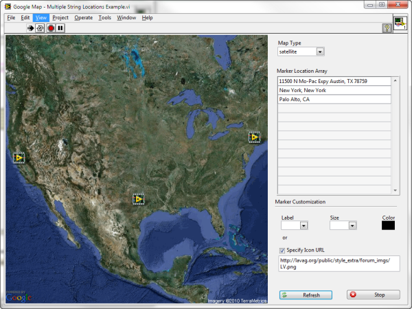
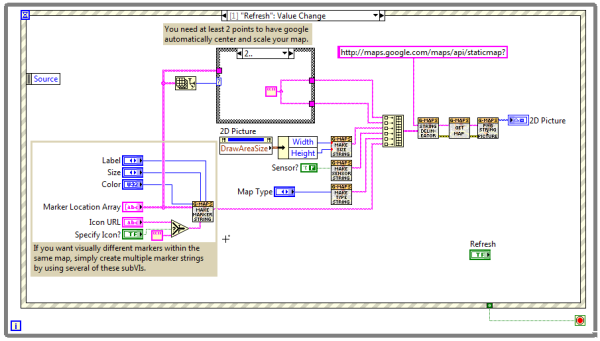
This example shows you how to incorporate Google maps with custom markers into your LabVIEW application.
- It uses the Google maps static API so it requires an internet connection to get new maps
- Pick between the different maps types (roadmap, satellite, terrain, hybrid)
- Provide an array of locations as either address strings or longitude and latitude
- Support for custom markers
- Uses a picture control rather than an embedded web browser
- Zip file contains re-usable set of subVIs which you can use for your own Google map VIs
Example code from the Example Code Exchange in the NI Community is licensed with the MIT license.
- Mark as Read
- Mark as New
- Bookmark
- Permalink
- Report to a Moderator
Hi,
I was wondering if there was any chance of getting this in Labview 8.5 (or compatible) format?
If you could I'd appreciate it.
Ken
- Mark as Read
- Mark as New
- Bookmark
- Permalink
- Report to a Moderator
I would also be interested in Labview 8.5 version if at all possible. Thanks, looks great!
- Mark as Read
- Mark as New
- Bookmark
- Permalink
- Report to a Moderator
Hi Team
I am looking for the solution for labVIEW and offline maps.
Best Regards
Luong.Tran
- Mark as Read
- Mark as New
- Bookmark
- Permalink
- Report to a Moderator
Hi,
How can we zoom the map?
- Mark as Read
- Mark as New
- Bookmark
- Permalink
- Report to a Moderator
Hi: I've downloaded the example file and have wired the input so it uses a list of longitude and latitude points from a CSV file. If I limit the data to 70 sets of points or less, I don't encounter an error. However, when I have more than that, I get an error that says "Error 0 occurred at URL too long- Get Map.vi". I was wondering if anyone had any ideas for a work around for this issue. Please let me know. Thanks, Nicole
